At the eastern entrance to the Palestinian village of Kfar Saba, located east of the city of Jaffa, there is a Jewish settlement occupying the name and location of the original village, reflecting the contradiction and audacity of the Israeli occupation, whose attempts are not confined to the displacement of the indigenous villagers but continue to plunder and forge history.
If a visitor led the way into the village, he/she would be astonished by the forged Jewish symbols filling two shrines, which the Israeli settlers have turned into “the graves of their prophets” with Torah verses graved on their walls. This is the lie they use as a pretext to wreak havoc on any historical site in 1948-occupied territories.
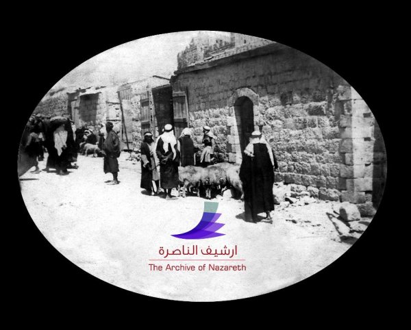
However, the village of Kfar Saba, which covers an area of 14 square kilometres, still retains its Arab and Islamic character. Its stones speak of its Palestinian history and Islamic civilization.
A Pure Islamic History
The village indeed has a pure Islamic history. According to the historian and archaeological tour guide specialising in antiquities, Fawzi Hanna, the village contains a Jewish city holding the same name as the original, but with an added letter. In this city, there are two main shrines, one of them, the larger, is located on its main road, and is attributed to one of the sons of the Prophet Jacob (peace be upon him).
According to Hanna, the Prophet Jacob and his sons were prophets, and as such, they have shrines scattered throughout the 1948-occupied territories, such as the shrine of the Prophet Reuben, the shrine of the Prophet Hud, and the shrine of the Prophet Joseph.
As for the second main shrine, according to Hanna, it is located near the sea road and was used by the Mamluks for postal services. Due to this, it was named the “Post Road” as it connected between Egypt’s capital of Cairo and the Levant. Mamluks established several khans for protection and services along this road, including Khan Jaljulia, Khan al-Tujjar, and Khan Bint Ya’qub.
Hanna also notes that there has been a khan in the village, ordered to be built by the Mamluk’s regional governor “Tankuz” al-Ashrafi al-Husami. The Khan’s construction was documented with an inscription on the eastern wall, recording the construction year as 740 Hijri (equivalent to 1940).
Hanna said “This khan was displaced by Israeli occupation. Then, a group of extremist Israeli Jews came and renovated it and turned it into a Jewish shrine, synagogue, and Torah study centre.”
They also replaced the green curtain that had the monotheistic declaration ‘There is no god but Allah, Muhammad is the Messenger of Allah”, and some verses from the holy Quran such as “What blessings you have are from Allah’ with” a black curtain bearing their symbols in gold letters.”
In the village, there is also an Islamic shrine called “Maqam Suraqah,” dating back to the era of the Mamluks that ruled that land. In addition, it has a water well to serve the visitors.
For Hanna, “The owner of this shrine is Suraqah ibn Malik, one of the most famous knights of the Quraysh during the Islamic period. He embraced Islam after attempting to kill the Prophet and his companion Abu Bakr while they were going to Al-Medina, in Suadi Arabia.
Despite the Judaization of the names and the forgery of inscriptions, the village’s shrines and khans still retain their Islamic and Mamluk architecture, which prevails, countering all attempts of settlement and Judaization.
Israeli Occupation of the Village
On Thursday, May 13th, 1948, Israeli occupation forces clamped down on the village, whose population was about 1,500 people, displacing its residents and destroying all of its facilities. As a result, the majority of its inhabitants settled in Qalqilya due to its proximity. There, a neighborhood was built for them named “Kafr Saba Neighborhood”, as a tribute to their hometown.
Another portion of the residents found refuge in several refugee camps like Balata and Al-Fara’a, as well as in the towns of Azun and Dhanabah. Another group left for Jordan and settled in cities such as Amman, Sweileh, Zarqa, Ain Al-Basha, Jerash, Irbid, and Al-Zarq.
The people of Qalqilya were in the front lines of defending Kafr Saba village in several battles against Zionist militias. Many of them were killed, and their names still echo in the minds of Kafr Saba Villagers. The martyrs were Asaad Suleiman Abu Sa’ada, Hussein Ali Abu Najm, Ragheb Ali Hawatreh, Ahmed Younis Al-Haj Hamdan, Abdul Rahman Abu Habla, Abdullah Al-Haj Issa, Muhammad Abu Hamdeh Jabarah, Muhammad Mahmoud Hamed Zahraneh, and Shaker Awwanat.
Location and Name
The displaced village of Kafr Saba is located approximately 3 kilometres west of Qalqilya and was administratively under Tulkarm during the British Mandate. Its elevation above sea level is approximately 620 meters.
The village was known as “Kafr Sabt” during the Crusader era. Some researchers believe that the word “Sabt” comes from Syriac and means “noble sheikh leading his people,” which was an honorific title for a saint.
However, many Kafr Saba residents believed that its name is derived from the Queen of Sheba, Bilqis, who passed through the area and it became part of her rule, hence the name “Kafr Saba, سبأ” with “Kafr” meaning a small village. Over time, its name evolved to Kafr Saba.
The village is part of the Palestinian Triangle and was established on the archaeological ruins of ancient Kafr Sabt, situated on a slightly elevated hill above sea level. Its founder and the one who defined its borders was Muhammad Al-Waleil (Al-Qatrawi), who came from Qatara in southern Palestine.
His definition of borders started when he travelled on his horse from Jiljulia to the Sayyed Ali area and from Basa to Maskah. He marked its borders with dry tree trunks. Consequently, it bordered Qalqilya to the east, approximately 3 kilometres away; Tubsar and the lands of the village of Al-Haram and Sayed Ali to the west, Maskah to the north, and Bayar ‘Adas and Jiljulia to the south.
It was part of the Bani Sa’ab district, with Tulkarm as the district’s capital, being the closest major Palestinian city, approximately 14 kilometres to the north.
Economic Life
Kafr Saba was renowned for its citrus orchards, various types of vineyards, and irrigated vegetables using artesian well water. The village had more than ten wells, including two owned by Palestinian families of Hajj Hussein Al-Alan, one owned by Abdul Halim Al-Nasr Al-Waleil, one by Tawfiq and Mohammed Ahmed Hamdan Waleil, one by Al-Najjar, one by Anis Swaylim, one by Hassan and Hussein Al-Aabid, one by Isma’il Mahmoud Al-Waleil, one by Dar Abu Ghazala, one by Sheikh Shamal Northeast of the school, and the eastern well near Prophet Yamin.
It was also known for its strategic location, as trade caravans would pass through it, stopping for rest and replenishment of water and food during their journeys between the Levant and Egypt, along the road known as the “Sultan’s Road,” which was used to transport goods to and from the port of Sayyed Ali.
Furthermore, the railway line extending between Haifa and Al-Lyd passed approximately 1.5 kilometres to the east, marking the boundary between the lands of Kafr Saba and the lands of Qalqilya, which were about 3 kilometres to the east.
Shortlink for this post: https://daysofpalestine.ps/?p=50304

