
DaysofPal- Recent Israeli maps point to a new phase in reshaping the military geography of the Gaza Strip, introducing the “Orange Line” as a key tool for expanding control and imposing new realities on the ground.
Distributed to international aid organizations in mid-March, the maps suggest a shift from managing military operations to actively redesigning space and population movement through fluid, restricted zones. The emerging framework reflects a transition toward the reengineering of territory and civilian presence under evolving military boundaries.
Expanding Control Over Territory
The Orange Line reportedly cuts off an additional 11 percent of Gaza’s area, complementing existing zones behind the previously established “Yellow Line.” Together, these areas place nearly two-thirds of the territory under effective Israeli control.
This expansion goes beyond conventional military demarcation. It signals the creation of a new geographic reality that significantly reduces the space available to Palestinians while concentrating populations into increasingly limited and fragile zones.
Although not officially published, the maps have reportedly been circulated among humanitarian agencies with instructions to coordinate movements within these newly defined areas. Observers say this approach allows Israeli authorities to impose facts on the ground without formal declaration.
Field reports indicate that the Orange Line is being used to establish buffer zones enforced through military means, often without clear guarantees for civilian safety.
Statements made in late March by Benjamin Netanyahu appear to reinforce this trajectory. He announced that more than half of Gaza’s territory had come under Israeli control, alongside continued military operations. Analysts view these remarks as aligning with developments on the ground that prioritize geographic consolidation over political negotiation.
Humanitarian Consequences
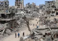
The impact of these shifting boundaries is increasingly visible in the humanitarian situation. Thousands of displaced civilians have found themselves within restricted areas without prior warning, as military lines continue to change rapidly.
This fluidity has created a persistent state of uncertainty, exposing residents to the risk of direct targeting, particularly near displacement camps and destroyed buildings now used as temporary shelters.
Reports indicate that more than 800 Palestinians have been killed since the last ceasefire announcement, many in areas adjacent to these evolving lines. The risks have also extended to international aid workers. At least three personnel affiliated with UNICEF and the World Health Organization were reportedly killed in zones between the Orange and Yellow lines, despite prior coordination.
Forced Population Redistribution
Experts suggest that the Orange Line functions as a mechanism for forced population redistribution, pushing civilians into narrow coastal areas lacking basic infrastructure and essential services.
This trend raises concerns about the long-term viability of life in Gaza, with approximately two million people facing increasingly constrained and coercive conditions, including the risk of displacement.
The expansion casts a shadow over international initiatives concerning Gaza’s future. By advancing territorial changes ahead of negotiations, the evolving map risks establishing facts that may prove difficult to reverse in any political settlement.
Research compiled by Palestinian analysts indicates that even the Yellow Line is no longer fixed, having shifted to include areas previously considered safe. This gradual expansion is reportedly being implemented through the establishment of observation points and the relocation of concrete barriers.
Over time, the Orange Line is becoming an invisible yet highly consequential boundary. Israeli forces are said to justify the use of live fire near the line on security grounds, despite the absence of clear markings on the ground.
This operational ambiguity increases the danger for civilians, placing them as “gray zones” where the risk of violence remains constant and unpredictable.
A Lasting Shift in Control
The continuation of this approach threatens to undermine remaining ceasefire arrangements and reflects a broader strategy of spatial control that extends beyond immediate military objectives.
In this context, maps themselves have become instruments of control, gradually redrawing boundaries in ways that reshape Gaza both demographically and geographically.
By the time international negotiations address the future of Gaza, the Orange Line may have already completed the demographic and geographic transformation of the territory. In this new paradigm, maps are no longer just tools of war, they are the blueprints for a permanent reality imposed by force, leaving the prospects for stability and Palestinian sovereignty increasingly out of reach.
Shortlink for this post: https://daysofpalestine.ps/?p=74263


