
DaysofPal- Husam al-Najjar’s world was governed by the seasonal rhythms prior to the war. Like his father before him, the fifty-year-old farmer would break the dawn silence in his fields east of Khan Younis, tending to his crops with the same quiet devotion he gave to his eight children.
Today, the man in his fifties stands on a raised mound of earth, gazing silently toward land he has not been able to reach for more than two years. What was once a short distance of a few hundred meters has become, in his words, an impossible gap. “It is farther than anywhere in the world,” he says.
A Line That Redefined Control
Al-Najjar’s land lies along what is known as the “Yellow Line,” a military boundary imposed by Israeli forces that has effectively redrawn the map of control inside the Gaza Strip. The line now encompasses roughly 53 percent of the territory.
With its expansion, vast agricultural areas have been reclassified as high-risk zones where access is prohibited and where troops treat them as open-fire areas. For farmers like al-Najjar, the line represents more than a geographic shift. It marks a forced separation from their livelihoods and a way of life.
He recounts repeated attempts to return to his land, each ending in retreat under gunfire from military vehicles. The constant presence and sound of those forces serve as a warning that approaching is no longer an option.
What was once a place of work and life has become a distant point, visible but unreachable, leaving its owner standing at the edge of a reality that has reshaped distance, control, and survival.
Satellite imagery has revealed the establishment of dozens of Israeli military positions inside Gaza, including at least 32 sites near the Yellow Line. These developments point to a rapid effort to impose new facts on the ground and consolidate long-term control over large areas of the enclave.
Many of these sites are equipped with electricity networks, lighting systems, communication towers, and engineering equipment. Others have been built on elevated and strategic locations, including areas in Jabalia and Beit Hanoun. Some are located near existing structures, including the vicinity of Hamad bin Jassim Hospital in Rafah.
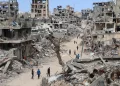
These positions are spread across areas that once included farms, residential buildings, and community spaces. In some cases, they have been established on the ruins of mosques and cemeteries destroyed during the war while land-clearing operations continue in neighborhoods such as Shujaiya.
Satellite data also indicates the construction of earth barriers stretching over 17 kilometers—about 40 percent of the line’s total length of 45 kilometers. Work to expand these barriers has continued in recent weeks, reinforcing the perception that the line is becoming a permanent feature.
Gradual Expansion and Civilian Impact
A report by The Guardian found that Israel has been gradually expanding its control by pushing the Yellow Line deeper into Gaza, increasing daily hardship for civilians. What was initially presented as a temporary ceasefire boundary has evolved into a tool for extending military control.
The line was first defined within a ceasefire agreement brokered by the United States in October, following nearly two years of war. It was intended as a temporary measure pending a later Israeli withdrawal. However, with the truce faltering after its initial phase, Israeli occupation forces began moving the line westward, expanding rather than reducing their presence.
This gradual shift has created confusion and danger for residents. Many wake up to find themselves suddenly inside what are considered “fire zones.” By December, the proportion of land under Israeli control had risen from 53 percent to 58 percent, with expansion continuing since then.
The Yellow Line is sometimes marked by movable yellow concrete blocks, while long earth berms, extending more than 10 miles, provide elevated positions for snipers and tanks. The addition of fortified military sites further suggests that this configuration may become entrenched.
Compounding the risk is the presence of what Israel refers to as the “Orange Line,” an undefined buffer zone extending between 200 and 500 meters beyond the Yellow Line. Any Palestinian presence within this area is treated as a potential threat. Because it lacks clear markings and shifts frequently, it creates a constant state of uncertainty and danger.
A Climate of Fear
The humanitarian consequences are severe. Civilian infrastructure, including shelters, has at times found itself inside dangerous zones without warning. Residents live under constant threat from gunfire and drones.
Testimonies describe a daily climate of fear. Many people avoid leaving their homes except when absolutely necessary, and children no longer play in the streets.
United Nations data indicates that more than 700 Palestinians were killed during a ceasefire period, including 269 near the Yellow Line and over 100 children.
Israel maintains that its measures are driven by security needs and insists that civilians are not targeted. However, UN High Commissioner for Human Rights Volker Türk has stated that targeting civilians, regardless of proximity to contact lines, constitutes a war crime.
Some analysts view the shifting of the Yellow Line as part of a broader strategy. Researcher Ahmad Ibsais has described it as a form of “annexation designed to avoid legal consequences.”
The Euro-Med Human Rights Monitor says that the establishment of these military sites represents a serious violation of the laws governing occupation, including the Fourth Geneva Convention and the Hague Regulations. International law, it stresses, does not permit an occupying power to permanently alter the legal or physical status of occupied territory.
The group also warns that the destruction of property must be strictly limited to immediate and temporary military necessity. Actions such as forced displacement, it notes, are explicitly prohibited and may constitute war crimes or crimes against humanity if carried out in a widespread or systematic manner.
A Fragmented Security Landscape
According to the organization, Israeli occupation forces have used these military positions to provide fire cover for armed groups operating under their direction, while also targeting civilian police structures. This has weakened local institutions responsible for maintaining order, contributing to a deliberate security vacuum within densely populated areas.
Such a dynamic creates a complex environment where regular forces and irregular groups operate in parallel, complicating accountability and increasing the risk of impunity. Civilians, in turn, are left exposed to multiple sources of violence in the absence of effective protection.
For Gaza’s residents, the Yellow Line is no longer a temporary measure but an evolving reality that continues to reshape daily life. It has altered geography, restricted movement, and intensified uncertainty.
Gaza’s “Yellow Line” Redraws Lives and Land, Deepening Civilian Hardship
DaysofPal- Husam al-Najjar’s world was governed by the seasonal rhythms prior to the war. Like his father before him, the fifty-year-old farmer would break the dawn silence in his fields east of Khan Younis, tending to his crops with the same quiet devotion he gave to his eight children.
Today, the man in his fifties stands on a raised mound of earth, gazing silently toward land he has not been able to reach for more than two years. What was once a short distance of a few hundred meters has become, in his words, an impossible gap. “It is farther than anywhere in the world,” he says.
A Line That Redefined Control
Al-Najjar’s land lies along what is known as the “Yellow Line,” a military boundary imposed by Israeli forces that has effectively redrawn the map of control inside the Gaza Strip. The line now encompasses roughly 53 percent of the territory.
With its expansion, vast agricultural areas have been reclassified as high-risk zones where access is prohibited and where troops treat them as open-fire areas. For farmers like al-Najjar, the line represents more than a geographic shift. It marks a forced separation from their livelihoods and a way of life.
He recounts repeated attempts to return to his land, each ending in retreat under gunfire from military vehicles. The constant presence and sound of those forces serve as a warning that approaching is no longer an option.
What was once a place of work and life has become a distant point, visible but unreachable, leaving its owner standing at the edge of a reality that has reshaped distance, control, and survival.
Satellite imagery has revealed the establishment of dozens of Israeli military positions inside Gaza, including at least 32 sites near the Yellow Line. These developments point to a rapid effort to impose new facts on the ground and consolidate long-term control over large areas of the enclave.
Many of these sites are equipped with electricity networks, lighting systems, communication towers, and engineering equipment. Others have been built on elevated and strategic locations, including areas in Jabalia and Beit Hanoun. Some are located near existing structures, including the vicinity of Hamad bin Jassim Hospital in Rafah.
These positions are spread across areas that once included farms, residential buildings, and community spaces. In some cases, they have been established on the ruins of mosques and cemeteries destroyed during the war while land-clearing operations continue in neighborhoods such as Shujaiya.
Satellite data also indicates the construction of earth barriers stretching over 17 kilometers—about 40 percent of the line’s total length of 45 kilometers. Work to expand these barriers has continued in recent weeks, reinforcing the perception that the line is becoming a permanent feature.
Gradual Expansion and Civilian Impact
A report by The Guardian found that Israel has been gradually expanding its control by pushing the Yellow Line deeper into Gaza, increasing daily hardship for civilians. What was initially presented as a temporary ceasefire boundary has evolved into a tool for extending military control.
The line was first defined within a ceasefire agreement brokered by the United States in October, following nearly two years of war. It was intended as a temporary measure pending a later Israeli withdrawal. However, with the truce faltering after its initial phase, Israeli occupation forces began moving the line westward, expanding rather than reducing their presence.
This gradual shift has created confusion and danger for residents. Many wake up to find themselves suddenly inside what are considered “fire zones.” By December, the proportion of land under Israeli control had risen from 53 percent to 58 percent, with expansion continuing since then.
The Yellow Line is sometimes marked by movable yellow concrete blocks, while long earth berms, extending more than 10 miles, provide elevated positions for snipers and tanks. The addition of fortified military sites further suggests that this configuration may become entrenched.
Compounding the risk is the presence of what Israel refers to as the “Orange Line,” an undefined buffer zone extending between 200 and 500 meters beyond the Yellow Line. Any Palestinian presence within this area is treated as a potential threat. Because it lacks clear markings and shifts frequently, it creates a constant state of uncertainty and danger.
A Climate of Fear
The humanitarian consequences are severe. Civilian infrastructure, including shelters, has at times found itself inside dangerous zones without warning. Residents live under constant threat from gunfire and drones.
Testimonies describe a daily climate of fear. Many people avoid leaving their homes except when absolutely necessary, and children no longer play in the streets.
United Nations data indicates that more than 700 Palestinians were killed during a ceasefire period, including 269 near the Yellow Line and over 100 children.
Israel maintains that its measures are driven by security needs and insists that civilians are not targeted. However, UN High Commissioner for Human Rights Volker Türk has stated that targeting civilians, regardless of proximity to contact lines, constitutes a war crime.
Some analysts view the shifting of the Yellow Line as part of a broader strategy. Researcher Ahmad Ibsais has described it as a form of “annexation designed to avoid legal consequences.”
The Euro-Med Human Rights Monitor says that the establishment of these military sites represents a serious violation of the laws governing occupation, including the Fourth Geneva Convention and the Hague Regulations. International law, it stresses, does not permit an occupying power to permanently alter the legal or physical status of occupied territory.
The group also warns that the destruction of property must be strictly limited to immediate and temporary military necessity. Actions such as forced displacement, it notes, are explicitly prohibited and may constitute war crimes or crimes against humanity if carried out in a widespread or systematic manner.
A Fragmented Security Landscape
According to the organization, Israeli occupation forces have used these military positions to provide fire cover for armed groups operating under their direction, while also targeting civilian police structures. This has weakened local institutions responsible for maintaining order, contributing to a deliberate security vacuum within densely populated areas.
Such a dynamic creates a complex environment where regular forces and irregular groups operate in parallel, complicating accountability and increasing the risk of impunity. Civilians, in turn, are left exposed to multiple sources of violence in the absence of effective protection.
For Gaza’s residents, the Yellow Line is no longer a temporary measure but an evolving reality that continues to reshape daily life. It has altered geography, restricted movement, and intensified uncertainty.
Shortlink for this post: https://daysofpalestine.ps/?p=74104


